The subsurface: Earth’s largest unmapped environment
Gravity is the same everywhere on Earth, right?
No, it’s not.
In high school physics, most of us learn that gravity is a constant: around 9.8 m/s² everywhere on Earth. In reality, gravity is not perfectly uniform. The difference is tiny, far too small for us to notice in everyday life, but it contains valuable information about what lies beneath the surface.
Think of Earth's gravitational field as a map of mass. Areas with more mass exert a slightly stronger gravitational pull, while areas with less mass exert a slightly weaker one. Several factors cause these variations:
- What's underground matters. Different rocks have different densities. Dense rocks contain more mass and therefore create a slightly stronger gravitational pull. Less dense materials create a slightly weaker “pull”. By measuring these subtle differences, you can identify changes in underground geology, buried structures, or hidden voids.
- Your position on Earth matters. Gravity becomes weaker as you move farther from Earth's centre. This means gravity is very slightly stronger in a valley than on a mountain peak because the valley floor is closer to the centre of the planet.
- Earth is constantly changing. Gravity also varies over time as mass moves around the planet. Melting glaciers, shifting groundwater and aquifer recharges all redistribute mass, creating measurable changes in the local gravitational field.
The variations in gravity are all so tiny that they can only be detected using special equipment called gravimeters. These sensors measure this “pull” at a single point. If you imagine gravity as a hill, this tells you how high you are at that specific point. This is useful, but it can be impossible even for the best gravimeters to measure these signals in real-world settings.
Gravity gradiometers work differently.
Instead of measuring the total gravitational pull at one point, they measure how gravity changes between two points. In the hill analogy, they measure the ‘slope’ rather than the ‘height’. This matters because imagine trying to measure how high a hill is if it kept moving up and down. Instead, gravity gradiometers are as if the ruler you are using to measure is stuck to the side of the hill; that way, you can always see how tall it is.
Because underground structures affect gravity, both gravimeters and gradiometers can be used to “see” things beneath the surface without digging. They are used to identify underground voids, buried infrastructure, geological structures, mineral deposits, groundwater resources, and areas of ground instability.
By detecting subtle variations in gravity caused by changes in subsurface density, these tools provide important information for safer construction, resource exploration, and environmental monitoring.
So why haven’t we mapped every subsurface in the country before now?
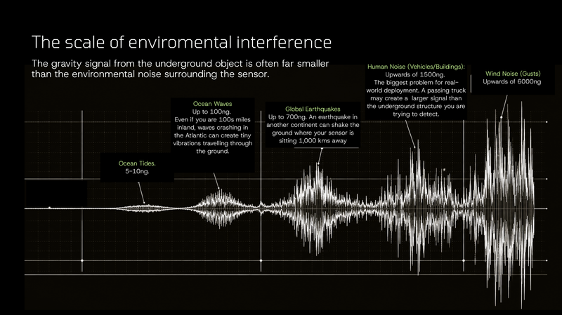
These classical sensors struggle outside of highly controlled environments because they are extremely sensitive to vibration, motion, and environmental noise. Even small disturbances from vehicles, machinery, or waves hundreds of miles away can overwhelm the tiny gravitational signals they are trying to detect.
Einstein’s equivalence principle creates one of the biggest challenges in gravity sensing: a sensor cannot easily tell the difference between gravity and motion. To the sensor, the gravitational pull from something underground, like a tunnel, salt dome, or ore body, looks almost identical to the vibration caused by the environment (e.g. passing traffic). This means environmental noise becomes mixed into the gravity measurement and creates major limitations for traditional gravity sensors:
- Small underground signals are often buried beneath environmental noise
- Making a sensor more sensitive does not solve the problem because it just detects more noise.
- Traditional systems often need to remain stationary for long periods to average out environmental disturbances and produce a usable reading
This gap in our understanding of the subsurface (underground and underwater) is a massive economic drain. Just think about it, every time a shovel hits a pipe that wasn't on a map, or a sinkhole opens under our feet, the clock starts ticking on a very expensive disaster. In the UK alone, our inability to accurately "see" the subsurface costs the economy billions annually just from accidental utility strikes.
This problem is multiplied across almost every single sector. Any industry that relies on understanding the subsurface (underground and underwater), is losing billions.
The challenge has always been separating these tiny gravitational signatures from the overwhelming noise of the real world. Every tunnel, void, buried asset, groundwater reservoir, geological structure, and navigation route leaves a gravitational signature that isn’t being fully captured. For the first time, advances in quantum sensing are making those signatures practical to measure in the real world.
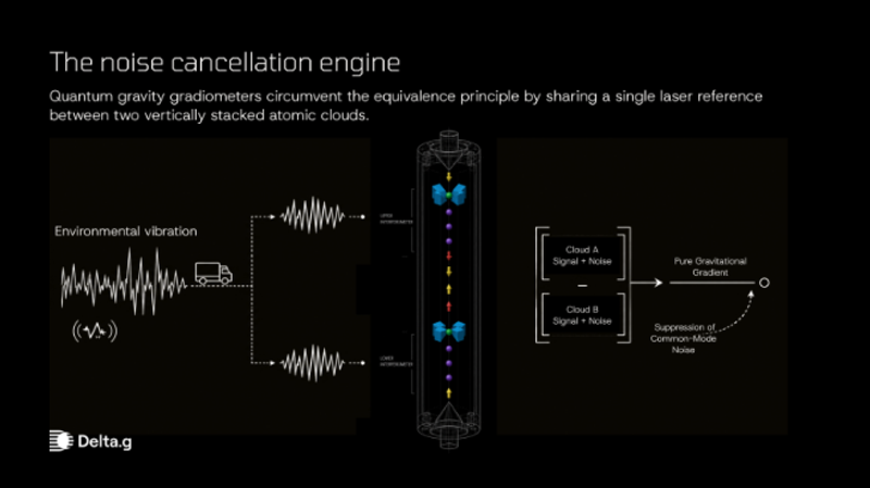
The Delta.g Quantum Solution
Our Quantum gravity gradiometry solves the noise problem through atom interferometry. Our patented hourglass approach uses clouds of atoms, cooled to near absolute zero, as "test masses." The breakthrough in noise rejection comes from vertically stacking two of these sensors and "sharing" a single laser reference between them.
Because the laser hits both clouds simultaneously, any environmental vibration is imprinted identically on both. When we subtract the readings, the vibration, the "common mode" noise, is cancelled out, leaving only the difference in gravity between the two heights. Think of our sensor like the ‘noise-cancelling headphones’ for the subsurface.
By eliminating the noise that has masked the subsurface for centuries, we are finally gaining the spatial intelligence required to build safely and navigate surely. Because the utility of this "Invisible Map" also extends into navigation.
We have mapped the topography of the Moon and Mars, yet we remain remarkably blind to the complex structures just a few meters beneath our feet. The map has always been there; we are just finally building the light to read it.
You’ll find us on the techUK stand at London Tech Week 2026.

To learn more about Delta G, click below:
Our team:
Alex Smith
Alex Smith
Alex joined techUK in September 2021.
Alex supports the development of the techUK marketing strategy, identifying and driving key campaigns across the techUK community that build our credibility, increase our influence, and provide thought leadership on the future impact of tech innovation across society, the economy, and the planet.
Prior to joining techUK Alex was Head of Marketing at UK Finance, the trade association for the banking and finance industry, where he led a team focused on commercial marketing strategies. Before that he was Head of Marketing at Payments UK supporting the payments industry to deliver world leading innovation.
- Email:
- [email protected]
- LinkedIn:
- https://www.linkedin.com/in/alex-smith-21467394
Authors
