Location-based solutions drive successful climate adaptation and mitigation (Guest blog from Esri UK)
Guest blog by Miles Gabriel, Head of Business Development, Climate & Disaster Response Programe Lead, Esri UK, as part of Climate Action at COP28 Campaign Week.
Introduction
What was once an impending climate crisis is now our global climate reality. Climate impacts have escalated to the point of endangering communities and evoking social urgency.
Executives and government leaders must do more than respond. They must prepare for and predict future climate conditions. This will involve analysing data, mapping assets, modelling climate impacts, and developing strategies for mitigation and adaptation.
First however, leaders need more clarity around climate risks. They need to know what is likely to happen, who and what will be affected, and when and where. They also need to see the implications, i.e. the costs of action or inaction.
Science & Technology
The good news is that we have the science and technology to deliver greater clarity and support mitigation and adaptation plans.
Climate science from organisations such as the Met Office is increasingly accessible (see the Climate Data Portal) in digital data formats that enable it’s reuse and integration with other information. This means that the risks faced by a business or community can be understood in the context of people, assets, operations, natural systems and specific geographic locations.
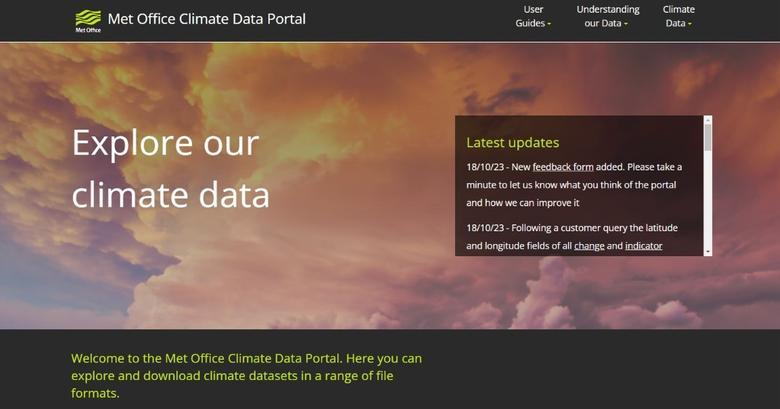
Met Office Climate Data Portal allows users to view and interact with a range of weather and climate related datasets, such as future extreme temperature projections.
Geography is essential to this understanding, and to tackling climate risks. Location intelligence, delivered via a modern geographic information system (GIS), gives decision-makers and stakeholders access to the required evidence from predictive simulations and risk analytics, displayed via real-time dashboards and map-based visualisations.
Examples
The White House Climate Mapping for Resilience and Adaptation (CMRA) Portal: Developed with the National Oceanic and Atmospheric Administration (NOAA), the US Department of the Interior and the US Global Change Research Program, CMRA helps communities assess their exposure to current and projected future climate hazards. It offers scientific data, in a visual and easy-to-understand format, to help us better understand, at a local level, what's happening with our changing climate and links this to US Government investment to overhaul infrastructure to make roads, bridges, railroads, power grids, water systems, transit routes, airports, and ports climate resilient.
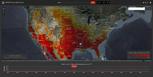
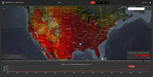
NOAA Future Heat Events maps show the total number of days over 95° F by county, to guide action for strategic climate adaptation and mitigation measures. The top map shows historic climate data for 2020 (54 days over 95° F), and the bottom map shows 2080 projections (122 days over 95° F) for Ouachita, Louisiana.
Cities are increasingly using big data and mapping technology to gain a deeper understanding of climate change.
The City of Prague is particularly vulnerable to extreme heat as it has more paved spaces, built-up areas and industrial infrastructure that can create heat islands. But Prague also contains a significant amount of green space and vegetation, the kind of areas that can offer respite.
Officials from IPR Prague are using GIS technology to view and analyse the city by integrating sensor-based measurement of temperature fluctuation, solar radiation and humidity with health and demographic information. This allows them to highlight, for instance, where there are high populations of seniors and young children, two populations at increased risk from high temperatures.
The next phase of Prague’s climate strategy will involve using GIS to construct intricate 3D models of the city’s microclimates and analysing the likely effects of adaptation strategies before the city invests time and money. These models will also provide a way to communicate these plans with other government agencies and the public.
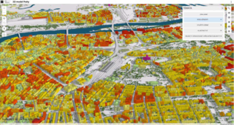
A 3D, interactive map of Prague shows models of the city’s microclimates to analyze the effect of mitigation strategies before investment and guide strategic climate action.
Conclusion
Much of the information within the above examples isn't new, and builds upon years of scientific knowledge and investment. Traditionally, however, these resources have been difficult to find and understand, particularly as they were not integrated with local or business data to provide a more complete picture. That's where GIS technology plays a key role, integrating information to help us understand our complex problems in the crucial context of location.
Most businesses and government organisations already employ location intelligence, relying on software and services from Esri, the worldwide leader in GIS technology. As a company known for its heavy focus on research and development, Esri prioritises engineering technology and solutions and curating authoritative data to support resilience and sustainability initiatives. Recently, Esri was recognised with the highest possible score for climate risk analytics by independent research firm Forrester. The firm’s analysis cited Esri® technology for its advanced data processing, visualisation, and threat modelling capabilities.
techUK - Committed to Climate Action
Visit our Climate Action Hub to learn more or to register for regular updates.
By 2030, digital technology can cut global emissions by 15%. Cloud computing, 5G, AI and IoT have the potential to support dramatic reductions in carbon emissions in sectors such as transport, agriculture, and manufacturing. techUK is working to foster the right policy framework and leadership so we can all play our part. For more information on how techUK can support you, please visit our Climate Action Hub and click ‘contact us’.
Authors
