Geospatial: Moving from Maps to Machine Learning
The term “Geospatial” is usually associated with maps and Geographic Information Systems (GIS) tools. But new technologies such as cloud based high performance processing power, the internet of things, and artificial intelligence & machine learning (AI/ML) are changing the Geospatial sector through a new generation of companies that don’t just visualise data but understand the data itself.
This means looking at the sources of data and its lineage (ie. reliability), the quality of that data (ie. how useable it is), and then finding the relationships between Geospatial and non-Geospatial data alike. This reflects a move from a world with high volumes of “structured” data that can be stored, analysed and visualised in a GIS system to a fast-moving and ever-changing environment where data is a combination of structured and unstructured data such as imagery, live video feeds, social media, open Government data, and crowdsourcing.
The new generation of Geospatial companies apply data science within a Geospatial context to find the critical insights that every organisation needs to stay ahead of the game. This growth in spatial data science has been accelerated through the COVID-19 working environment where data and location now drive key decisions across Government and private sector.
Human & Machines: redefining roles
Asking someone to make decisions based on huge amounts of real-time, diverse and complex datasets is no longer an option. The growth of AI/ML tools will enable greater insight than ever before so in the future we will see AI/ML applications moving organisations from situational awareness, to decision support, to highly automated decision-making. Initially, this will be far more prevalent for high volume, low risk & mundane tasks where immediate cost savings can be made.
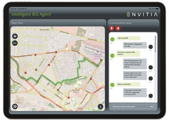
Intelligent Agent Case Study
Envitia is one such spatial data science company. Envitia’s architecture creates a separate data layer for incoming data that feeds into the AI/ML and visualisation layers to ensure the right data from the right source, with the right quality is available to many different AI/ML applications rather than all data being loaded into one system. Critically, that data is automatically updated to ensure it remains accurate and accessible to all the different applications and tools.
For example, in a military context a commander might need to work out the quickest route to a location whilst avoiding the risk of encountering areas of civil unrest or improvised explosive devices (IEDs). A voice activated interface makes it easy for the commander to simply ask questions and get the answer they need to complete their task. Using Natural Language Processing (NLP), the Intelligent Agent identifies relevant datasets such as historic IED locations, dates of incidents, time of day, weather, traffic, and known civil unrest hotspots to feed the model and offer a predictive decision. This case study is all about the data and not the map as having searchable, relevant and accurate data is critical, albeit the map remains a great user interface to visualise the output.
Spatial Data Science as a transformation accelerator for other sectors
The Geospatial input for projects is the interface between the virtual world and the real world ie. “everything happens somewhere” (an overused term within the Geospatial community but still relevant). As Machine Learning, Deep Learning, Autonomous Vehicles and Virtual/Augmented Reality technology develop we’re going to see a transformation within the Geospatial sector moving from dashboards and map visualisation to spatial data science which, in turn, will open deeper and forward-looking insights that enable transformation across many other sectors including utilities, farming, retail and smart cities.
You can read more insights from techUK's #GeospatialFuture campaign here!